California Wildfire Projections: Current Data, Future Efforts
2020 has been a record-setting year for wildfire in California. As of the writing of this blog post, more than 4.1 million acres have burned, more than double the previous annual total of 1.7 million acres burned in 2018, and California’s 2020 wildfire season is not yet over.
Climate scientists project that in coming decades, California will see increases in mean annual area burned and more frequent extreme wildfires. Some of this increase in wildfire occurrence and intensity is the result of climate change, with additional anthropogenic factors like forest management, carbon emissions, population growth, and development patterns also contributing. Because wildfire projection is multifactorial and complex, Cal-Adapt and the Pyregence Consortium hosted a webinar that explored how wildfire projections are created, how they should and should not be interpreted, and how projection and modeling methods will be updated for California’s Fifth Climate Change Assessment.
Here’s a link to the full video of the webinar, and a written summary is provided below.
Fourth Climate Change Assessment Wildfire Projections
To start the webinar, Dr. Leroy Westerling offered an overview of wildfire modeling techniques, particularly those that informed California’s Fourth Climate Change Assessment. Dr. Westerling’s presentation highlighted that:
- Wildfire modeling and projection must take into account a suite of environmental and social variables like land use scenarios, forest management practices, climate change projections, topography, vegetation patterns, ignition causes, and historic fire occurrence
- Annual area burned and extreme wildfire event frequency are both projected to increase in California
- Much of this increase is anticipated to occur in the Sierra Nevada, particularly in the northern parts of the state
- Wildfire in California will worsen if tree mortality, dead heavy fuels, and biomass continue to accumulate
- Fuels treatment has the potential to mitigate wildfire frequency, extent, and severity
- Wildfire modeling is made more complicated by the potential for concurrent stressors, like prolonged drought and an extended, intense wildfire season occurring simultaneously
Wildfire Data Projections on Cal-Adapt
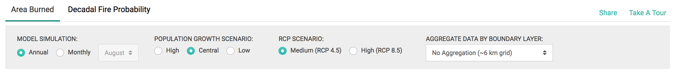
Dr. Westerling’s Fourth Climate Change Assessment wildfire modeling data is accessible through Cal-Adapt. Cal-Adapt presents both projected area burned and decadal wildfire probability.
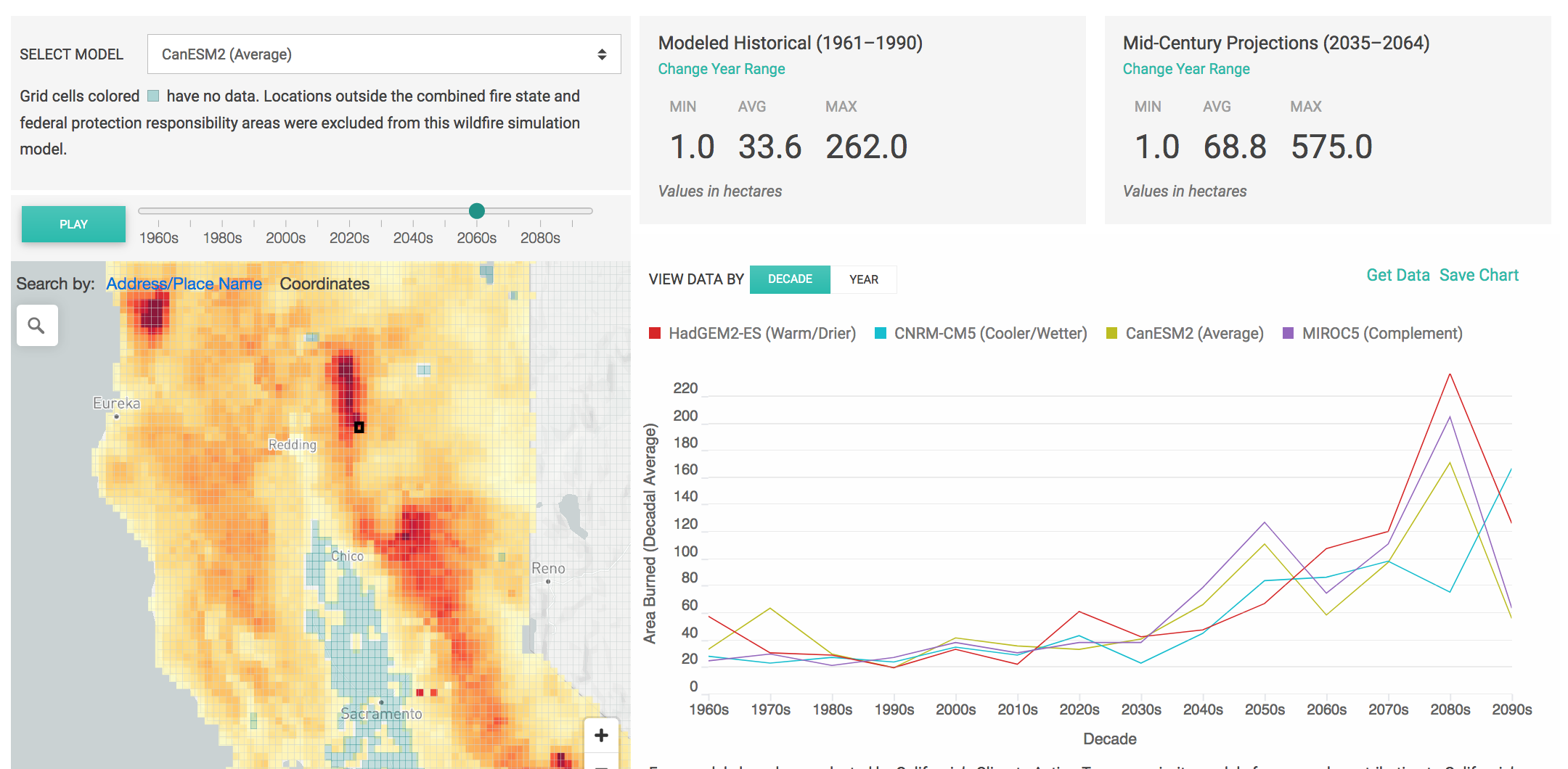
Projected data is available for California’s four priority general circulation models (GCMs), two possible emissions scenarios (representative concentration pathways 4.5 and 8.5), and three population growth scenarios (low, medium, and high). Data is initially presented in 6 km x 6 km grid cells. The user can aggregate data by other boundary layers like counties and watersheds. Please note that data is not available for some urban and agricultural areas, as such areas were not included in wildfire models run for the Fourth Climate Change Assessment.
Best Practices for Working with Climate Projections
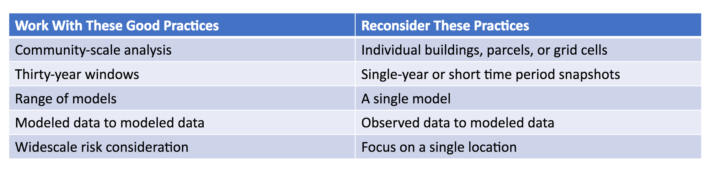
Dr. Owen Doherty offered best practices for working with climate change data, including wildfire projections.
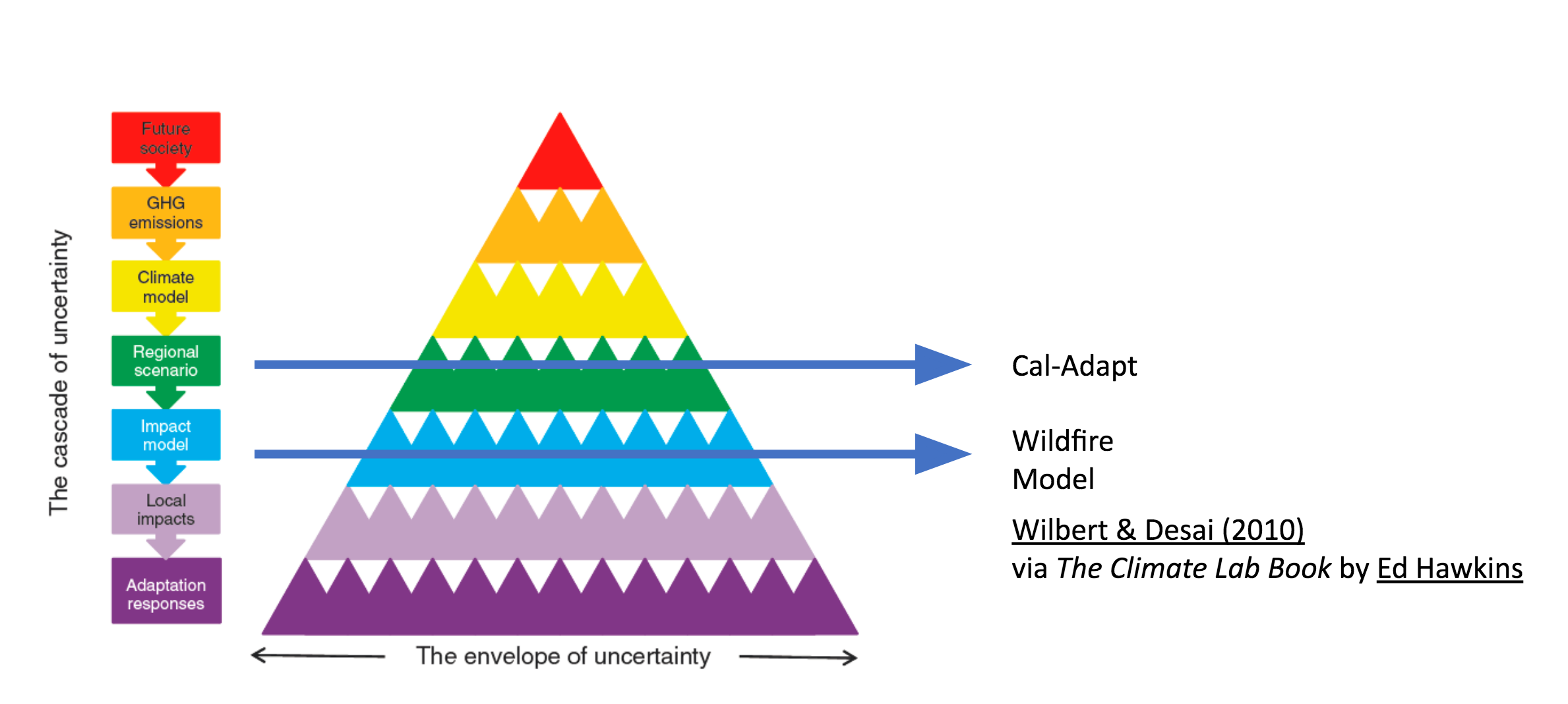
First, a user must recognize that all climate projections carry with them a degree of uncertainty. This does not mean that we do not know anything about our climate future; we can say with great certainty that California is and will continue to experience warmer temperatures, more variable drought and precipitation patterns, and a greater frequency of extreme climate events. However, the specific trajectory of our climate future is bounded by an envelope of uncertainty, also known as a range of future climate conditions, that gets wider the further out in time we look and the more factors we incorporate in modeling. A lot of this range is attributable to future human decisions like energy consumption and land use practices that will impact emissions. In general, climate trends remain clear, and the more factors that are involved in modeling, the greater the corresponding uncertainty that surrounds specific modeled values.
Because of this, Dr. Doherty recommends that climate change data users:
- Consider more than one data point (both spatially and temporally)
- Look at climate change data aggregated over longer periods of time, like 30-year time windows, rather than single years
- Include as many climate model runs as feasible for you to capture the full range of projected outcomes, as well as trends in central tendency
- Compare model projections to modeled historical data
Wildfire Data in California’s Fifth Climate Change Assessment
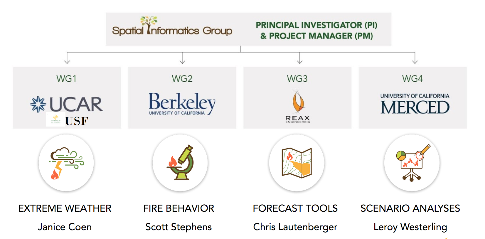
Finally, Dr. David Saah and Dr. Leroy Westerling presented the wildfire modeling consortium and process that will support California’s Fifth Climate Change Assessment. The inputs, process, and outputs of this anticipated effort are illustrated in the figure below.
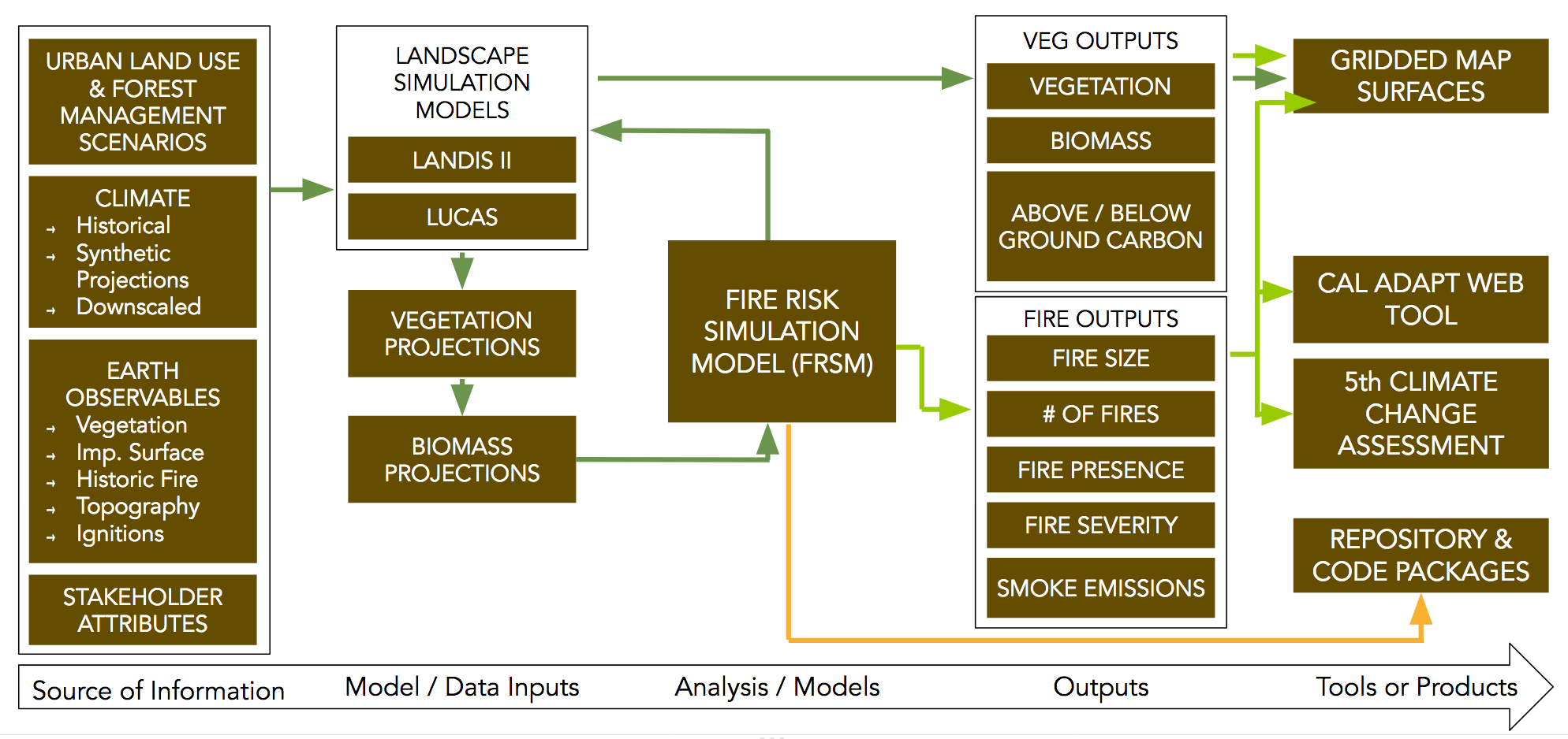
Wildfire modeling for the Fifth Assessment is expected to incorporate the newest science in modeling and management. Outputs will include projections for area burned, as well as smoke production (PM2.5). For more information, keep an eye on the web page and publications from the Pyregence Consortium.