
Introducing Cal-Adapt’s New Look and Features
Learn about the revamped Cal-Adapt website.
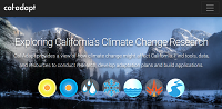
News and updates on Climate Tools, Data and Resources on Cal-Adapt
Learn about the revamped Cal-Adapt website.
Learn how to use the caladaptR package to access climate data on Cal-Adapt: a virtual workshop for R users.
A preview of our new Get Started guide and other Help content developed for Cal-Adapt in response to user feedback.

A three-day virtual workshop on Climate Data and Analytics for California's Ambitious Climate and Energy Goals.
Cal-Adapt team has created a new tool to support climate change adaptation practitioners in addressing the threats posed by rising temperatures, changing precipitation patterns, and climate change-influenced wildfire patterns.

An overview of past and current wildfire modeling techniques used in California's climate assessments and best practices for using this data.
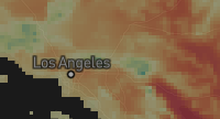
The Maps of Projected Change tool allows you to compare long-term historic climate conditions with projected future climate conditions in a quick geographic display.

The new data download tool helps users find, select, aggregate, and download climate data for a suite of projections and variables.
The GIF was recently awarded AWS Cloud Credits for Research to explore, prototype, and develop the use of distributed cloud computing resources to build the next-generation of Cal-Adapt which will provide users with fast, dynamic, interactive exploration of climate variables.

This new tool explores hourly sea level projections at selected Tide gauge locations along the California coast.

This new tool explores data for two 20-year drought scenarios derived from LOCA downscaled meteorological and hydrological simulations, one for the earlier part and one for the latter part of the 21st century.
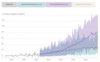
The Extreme Heat Tool utilizes LOCA downscaled daily maximum and minimum temperature data to visualize the frequency and duration of extreme heat events for California.
The new Cal-Adapt (Cal-Adapt 2.0) dramatically expands the capacities of the initial version of Cal-Adapt, which was released in 2011, in the following ways: New climate projections More powerful visualizations Improved access to primary data and a new public API Connections with supporting…
Through Cal-Adapt, users can download projected climate data associated with 32 General Circulation Models (GCMs, also known as Global Climate Models). This suite of models—known as CMIP5—was used as the basis for the United Nation’s Intergovernmental Panel on Climate Change (IPCC) Fifth Assessment…
We would like to feature how people around California are using Cal-Adapt for planning, assessment, research, teaching, and more. If you want to share your experiences, we would love to hear from you! Email us your story at support@cal-adapt.org with the heading User Story.